





マスメディアでもかなり取り上げられましたが、2026年9月4日(現地時間)、アフリカのトーゴによる国連決議案が賛成多数で採択されました。
- 国連総会、世界地図に「イコールアース図法」使用促す決議 アフリカの実際の大きさ反映
- 世界地図、なぜメルカトル図法をやめるのか?
- イコールアース図法とは|面積が正しい世界地図と国連決議
- 「『小さな島国』に見える日本ですが…」世界地図が“イコールアース図法”に変わるとどうなる?〈池上彰さんが解説〉
- 【イコールアース図法】国連推奨の世界地図めぐり製作者が明らかに 日本語版は“北方領土の色変更”
日本では、メルカトル図法の面積の歪みと、北方領土の扱いがロシア寄りになっている点ばかりが強調されていましたが、決議案の原文をよく読むと、地図学やGIS関係者にとってはかなりよいことを書かれていて、その内容がまったく報道されていなかったのでここで補足します。
経緯
これまでの経緯はおおまかに次のとおりです。
- 2025年4月、アフリカの市民団体を中心に ”Correct The Map” キャンペーンが始まり、「メルカトル図法をやめてイコール アース図法を勧める」活動を展開、アフリカ連合も指示を表明
- 2026年4月、アフリカのトーゴが旗振り訳となり、国連決議案を準備していることを表明
- 2026年9月4日(現地時間)、国連決議案が賛成多数で採択された
- “Correct the map”: global cartographic representation and promoting equitable representation of rebalancingthe world’s regions, particularly Africa
- “地図を正す”:世界の地図上の表現バランスを是正し、世界の地域、特にアフリカの公平な表現を促進する
決議案の要約
報道された内容だけだと、「メルカトル図法は面積が正しくないので、面積が正しいイコールアース図法を使うべきだ」という印象を受けて、どんな地図であってもメルカトル図法はダメで、イコールアース図法が正解、みたいな印象に受け取れましたが、「大陸の面積が重要な場合において」と前置きが書かれていますし、イコールアース図法を含む正積図法、と説明されています。また、地図投影法や地理空間情報に関する教育の推奨を支援することが書かれていて、これはかなり重要なポイントです。決議案の要約を箇条書きで示すと次のようになり、マーカーを引いた部分が報道で触れられていなかったポイントです。
- 世界中で広く使用されているメルカトル図法は、面積の表現という観点から、特に赤道から遠く離れた大陸の面積を著しく歪め、その結果、アフリカやその他の地域の面積が比例的に縮小して表示されることを認識
- 「イコール アース」地図投影法は、大陸の陸地の大きさをより正確に表現するものであり、この点において、世界の地図表現の精度を向上させるための適切な選択肢であることを宣言する
- 大陸の実際の面積が極めて重要な場合において、その面積をより正確に再現する「イコール アース図法」および正積図法を採用、普及、活用するよう推奨
- 大陸のより正確な面積を反映させるため、地理空間教育、研究、イノベーションおよび技能開発に関連する教育カリキュラムの改善を支援すること
補足
- このような政治的な活動は1970年代にもありました。「ペータースの論争」で調べてみて下さい。
- 少なくとも、日本の地図学者(北田宏蔵や野村正七の文献)は、かなり以前から「世界地図にメルカトル図法はふさわしくない」ことを訴えていました。
- 日本の学校地図帳においては、高度経済成長期にはすでにメルカトル図法は使われておらず、世界地図の円筒図法ではミラー図法が使われています。ミラー図法とメルカトル図法の違いが分かる人は少ないため、地図帳にはメルカトル図法が使われていると勘違いしているので、日本のマスメディアでも盛り上がったと考えます。
- フランス外務省は2026年9月4日、外交文書や公式発表で使用する世界地図の図法を従来のメルカトル図法からエケルト第4図法(Eckert IV)へ変更すると発表しましたが、一般的に扱うにはエケルト第4図法もイコールアース図法も大した違いはありません。
国連決議案に関連する情報は4月にも記事を書いていますので、こちらも参照してください。
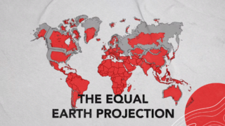
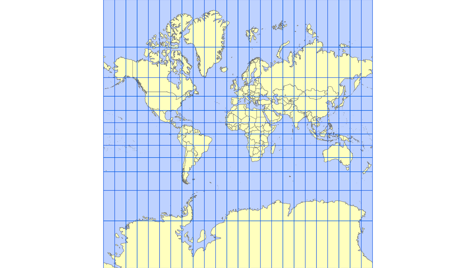
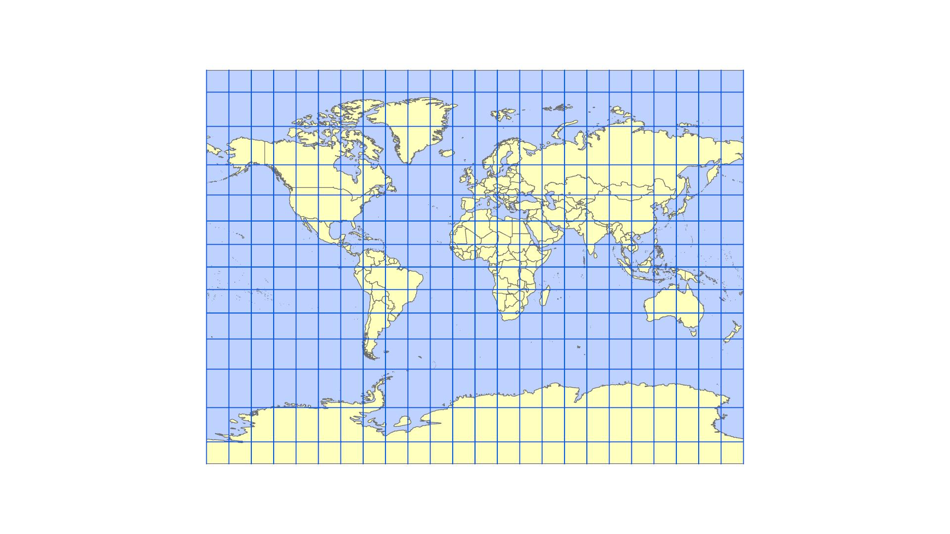
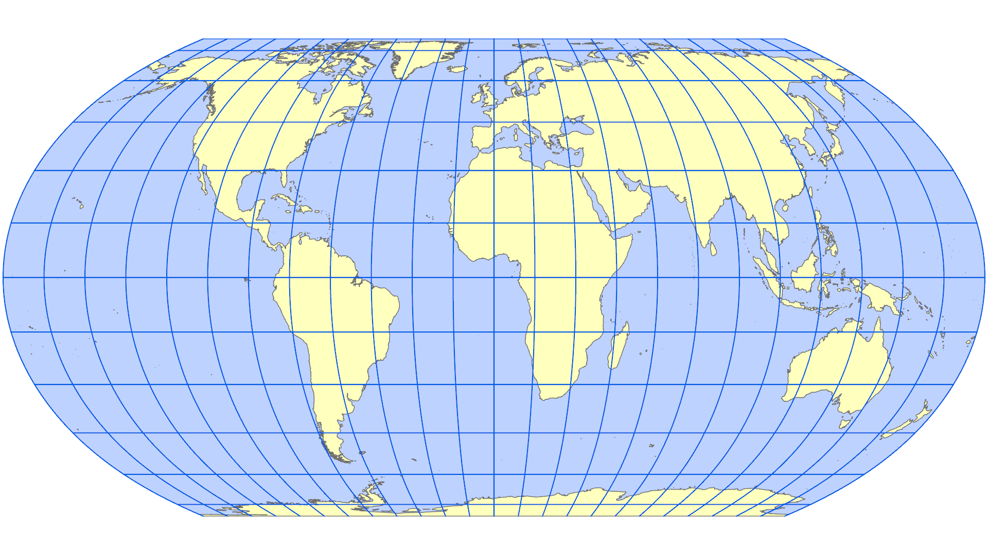
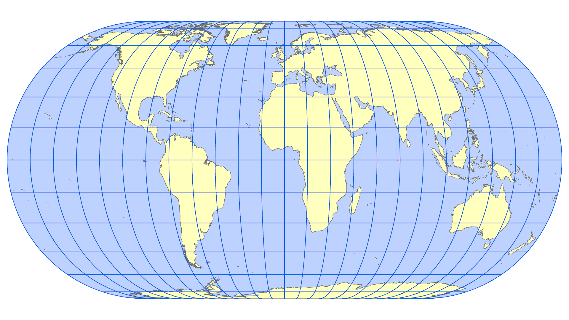
地図による比較
注:縮尺は同一ではありません。
翻訳全文(DeepL使用)
「地図を正す」:世界地図の表現バランスを是正し、世界の地域、特にアフリカの公平な表現を促進する
総会は、
国家の主権的平等、人間の尊厳の尊重、および国家間の友好関係の確立を含む、国連憲章の目的および原則に導かれ、
「すべての人間は、生まれながらにして自由であり、尊厳および権利において平等である」とする『世界人権宣言』¹に謳われた平等および非差別の原則を再確認し、
また、平等および表現の自由の権利を促進する『市民的及び政治的権利に関する国際規約』²ならびに『経済的、社会的及び文化的権利に関する国際規約』³の関連規定を再確認し、これには、国境を問わずあらゆる種類の情報および思想を求め、受け取り、伝達する自由、教育を受ける権利、および文化的生活に参加する権利が含まれる、
2015年9月25日の「私たちの世界を変革する:持続可能な開発のための2030アジェンダ」と題する決議70/1を想起し、同決議において、あらゆるレベルにおいて、すべての人々が公平かつ質の高い教育を受けられるよう確保する必要性を再確認したことを踏まえ、
また、包括的かつ公平で質の高い教育を促進するとともに、批判的思考能力の育成および諸国民間の相互理解を深めるという、国連教育科学文化機関(ユネスコ)の使命を想起し、
世界地理空間情報管理専門家委員会が強調したように、地理空間情報が、効果的なガバナンス、証拠に基づく意思決定、および持続可能な開発のための基礎的なインフラとして果たす不可欠な役割を認識し、
2022年7月22日の経済社会理事会決議2022/24を想起し、同決議において、同理事会が、特に開発途上国におけるグローバル地理空間情報管理の調整と一貫性を改善する必要性を強調したことを踏まえ、
グローバル地理空間情報管理専門家委員会および国連統合地理空間情報フレームワークの取り組みに留意し、
地図による表現は地理空間情報の不可欠な構成要素であり、世界規模での領土の実情に対する認識と理解に永続的な影響を及ぼすことを強調し、
地図は、世界に対する認識や人々の集合的想像力を形作る、教育、科学、文化における基本的な手段であることを考慮し、
「アフリカ文化ルネサンス憲章」、とりわけアフリカの遺産の修復および強化に関する第3条を想起し、
歴史的に受け継がれてきた大陸の大きさに関する特定の地図上の歪みが、大陸に対する誤った認識の一因となり、とりわけ集団的想像力や知識体系においてアフリカが象徴的に軽視される結果を招いてきたことを認識し、
航行、地図作成、気候変動対策、およびリスク管理に不可欠な世界測地基準枠組みに向けた国際協力を強化することを目的とした、2015年2月26日の決議69/266を想起し、
様々な地図投影法が、異なる手法を用い、異なる地図学的特性を保持しながら、長年にわたり開発されてきたこと、また、単一の投影法では地球の曲面を平面上に完全に表現することはできないこと、 したがって、各投影法は特定の目的に適していることを認識するとともに、本決議は特に、世界の各地域の相対的な大きさおよびその表面積の比例的な表現を保持する投影法に重点を置いており、航海目的での地図資料の使用に関する確立された慣行を損なうものではないことに留意し、
16世紀に航海目的で考案されたメルカトル図法は、赤道から遠く離れた北半球および南半球の陸地において著しい歪みを引き起こし、赤道地域を不利益に扱うにもかかわらず、教育、メディア、デジタル、および公的資料において依然として広く使用されていることに留意し、
この歪みが、アフリカ、ラテンアメリカ、南アジアの知覚される大きさを過小評価させ、世界に対する不均衡な見方を永続させる一因となっていることを懸念をもって留意し、
公平な開発を促進する必要性を考慮し、大陸の大きさに関する地図上の歪みが、南部地域における社会経済的実情、インフラ需要、開発の可能性、および繁栄の規模を過小評価させる一因となっていること、また、それが環境、地政学、安全保障の各分野における偏見を助長し得ることを強調し、
「第2次アフリカ系の人々のための国際10年(2025年~2034年)」の宣言を歓迎し、この期間が歴史的な不正義を構成する諸問題に取り組むのに適していることを考慮し、
また、2024年9月22日および23日にニューヨークの国連本部で開催された「未来サミット」を歓迎し、同サミットにおいて「未来のための協定」と題する決議79/1およびその附属書が採択されたことを踏まえ、とりわけ、歴史的かつ構造的な不平等の残滓を排除し、あらゆる形態の差別を根絶する必要性を強調し、
アフリカ連合が2025年を「賠償を通じたアフリカ人およびアフリカ系の人々への正義」の年と宣言したこと、ならびに2026年2月にアディスアベバでアフリカ連合の国家元首・政府首脳会議により採択された決定 Assembly/AU/Dec.942 (XXXIX)を留意し、同決定は2026年2月にアディスアベバで開催されたアフリカ連合国家元首・政府首脳会議において採択されたものであり、2026年から2035年までの期間を、賠償を通じたアフリカ人およびアフリカ系の人々への正義に捧げる行動の10年間として承認するものである、
アフリカ連合の国家元首・政府首脳会議が、2025年12月8日から12日にかけてロメで開催された第9回汎アフリカ会議の最終宣言および、アフリカ連合と加盟国に対し、大陸の地図上の不均衡な表現を是正するよう国連に正式な要請を行うよう促したその勧告に留意した決定Assembly/AU/Dec.955 (XXXIX)を念頭に置き、
2026年2月にアディスアベバで採択された、アフリカ連合(AU)国家元首・政府首脳会議による「地球儀上のアフリカ地図の是正」イニシアチブに関する決定Assembly/AU/Dec.959(XXXIX)に留意し、
すべての大陸、特にアフリカの大きさをより正確に表現する「イコール・アース(Equal Earth)」地図投影法がアフリカ連合によって採択されたことを満足をもって留意し、
大陸の大きさに関する地図上の歪みを是正することは、正確な地理的知識、歴史的真実、教育および意識啓発を促進し、人々の相互理解を促進するものと理解される「認知的正義」および「記念的賠償」の行為を構成すると確信し、
1. 歴史から受け継がれてきた大陸の大きさに関する地図上の歪みは、認知的、教育的、文化的、地政学的、社会経済的な影響を及ぼし、歴史的な偏見を構成するものであり、その是正は、特にアフリカ大陸に関して、認識、正義、および開発を促進するものであることを確認する;
2. 世界中で広く使用されているメルカトル図法は、面積の表現という観点から、特に赤道から遠く離れた大陸の面積を著しく歪めており、その結果、アフリカやその他の地域が比例的に縮小して表示されていることを認識する;
3. 「イコールアース図法(Equal Earth)」が、大陸の陸地の大きさをより正確に表現するものであり、この点において、世界の地図表現の精度を向上させるための適切な選択肢であることを宣言する;
4. 地球のより正確かつ科学的に妥当な地図表現を推進する必要性を強調する;
5. 加盟国、国際機関およびその他の関連機関に対し、大陸の大きさが極めて重要な場合において、大陸の実際の面積をより正確に再現する「イコールアース図法(Equal Earth)」および正積図法を採用、普及、活用するよう奨励する;
6. 関連する国連の枠組みに従い、デジタルおよび印刷物の地図作成ツールにおいて大陸の大きさをより正確に表現することを目的とした国際基準の策定を奨励する;
7. 国連教育科学文化機関(ユネスコ)、国連開発計画(UNDP)、地球空間情報管理専門家委員会、宇宙問題局、およびその他の関連する国連機関に対し、それぞれの任務に従い、必要に応じて、アフリカ連合を含む地域機関や学界と協力し、以下のことを行うよう要請する:
(a) 必要に応じて、各大陸の正確な大きさを反映するよう、より正確で国際的に認められた地理空間、測地学および地図作成の基準を推進すること;
(b) 各大陸のより正確な大きさを反映するよう、地理空間教育、研究、イノベーションおよび技能開発に関連する教育カリキュラムの改善を支援すること;
(c) 大陸の実際の表面積に合致した、権威ある科学的に正確な地理空間情報および地図の作成と配布を奨励すること;
(d) 各国の地理空間能力を強化すること;
8. 世界の技術プラットフォームに対し、国連の原則、基準および指針に従い、地球の「イコールアース図法(Equal Earth)」を含む、より正確な地図表現を促進する観点から、加盟国および地域機関と建設的な対話を行うよう要請する;
9. 技術企業およびデジタル分野の関係者に対し、必要に応じて、適用される国連の原則、基準および指針ならびに国際法を考慮に入れ、大陸の大きさの表現において透明かつ包摂的な慣行を促進するよう要請する;
10. 加盟国、国際機関および市民社会組織に対し、地図投影法の手法(その特性、限界および適切な適用を含む)をユーザーに説明するよう要請するとともに、各投影法が特定の地図作成上の目的を果たすものであることを認識した上で、情報通信技術や人工知能などを通じて、関係する住民および一般市民の間で、地理的知識、戦略的理解、ならびに集団的アイデンティティにおける大陸の大きさの地図表現の文化的・歴史的意義に対する認識を強化することを目的とした啓発活動を実施するよう要請する;
11. 加盟国に対し、以下のことを奨励する:
(a) より正確な大陸の大きさに関する認識を高めるため、地図学の批判的指導を学校カリキュラムに組み入れること;
(b) 用途に応じて、大陸の大きさや地理的実情をより正確に反映する地図表現(「イコール・アース」地図投影法を含む)の利用を促進すること;
(c) 教育、科学、メディアのステークホルダーに対し、地図投影法の偏りに関連する問題についての認識を高めること;
12. 加盟国、国際機関、学界および専門機関に対し、以下のことを要請する:
(a) 国連の原則、基準および指針に従い、大陸の大きさをより正確かつ権威ある形で地理空間的に地図表現するための、国際的に認められた基準、指針および優良事例を策定、採択し、普及させること;
(b) 地図投影法の分野における研究とイノベーションを促進すること;
13. 地図作成および地理空間情報の分野において、各国の異なる状況を考慮しつつ、南北協力、南南協力、および三角協力を促進することの重要性を強調する;
14. 開発途上国、特にアフリカ諸国、後発開発途上国、内陸開発途上国、小島嶼開発途上国、中所得国、および紛争中・紛争後の状況にある国々において、地図作成、 ジオマティクス、測地学、および地理空間技術の分野における能力構築を奨励する。これには、国際協力、技術支援、研修、知識の共有、相互に合意された条件に基づく技術移転、地理空間データへのアクセス改善、ならびに各国の地理空間情報インフラ整備への支援などが含まれる;
15. 全世界における大陸の大きさのより正確な表現を促進するため、すべての加盟国に対し、「地図を正そう(Correct the map)」イニシアチブを推進するよう要請する;
16. 事務総長に対し、第83回総会まで(同会期を含む)にわたり、既存の資源の範囲内で、必要に応じて、総会に提出される関連する既存の報告書において、本決議の実施状況に関する情報を提供するよう要請する;
17. 第83回総会の暫定議題に、「教育および社会経済的目的のための大陸の正確な地図表現の促進ならびに開発途上国の地理空間能力に対する技術支援の強化」と題する項目を含めることを決定する。
原文
“Correct the map”: rebalancing global cartographic representation and promoting equitable representation of the world’s regions, particularly Africa
The General Assembly,
Guided by the purposes and principles of the Charter of the United Nations, including the sovereign equality of States, as well as respect for human dignity and the establishment of friendly relations among nations,
Reaffirming the principles of equality and non-discrimination enshrined in the Universal Declaration of Human Rights,1 according to which all human beings are born free and equal in dignity and rights,
Reaffirming also the relevant provisions of the International Covenant on Civil and Political Rights 2 and the International Covenant on Economic, Social and Cultural Rights, 3 which promote equality and the right to freedom of expression, which includes the freedom to seek, receive and impart information and ideas of all kinds, regardless of frontiers, the right to education and the right to participate in cultural life,
Recalling its resolution 70/1 of 25 September 2015, entitled “Transforming our world: the 2030 Agenda for Sustainable Development”, through which it reaffirmed the need to ensure access for all to equitable and quality education at all levels,
Recalling also the mandate of the United Nations Educational, Scientific and Cultural Organization to promote inclusive, equitable and quality education, as well as the development of critical thinking and mutual understanding among peoples,
Recognizing the essential role of geospatial information, as highlighted by the Committee of Experts on Global Geospatial Information Management, as a fundamental infrastructure for effective governance, evidence-based decision-making and sustainable development,
Recalling Economic and Social Council resolution 2022/24 of 22 July 2022, in which the Council underlined the need to improve coordination and coherence of global geospatial information management, particularly in developing countries,
Taking note of the work of the Committee of Experts on Global Geospatial Information Management and the United Nations Integrated Geospatial Information Framework,
Emphasizing that cartographic representations constitute an essential component of geospatial information and have a lasting influence on the perception and understanding of territorial realities on a global scale,
Considering that maps constitute a fundamental educational, scientific and cultural tool that shapes the perception of the world and the collective imagination of peoples,
Recalling the Charter for African Cultural Renaissance, in particular article 3 relating to the rehabilitation and enhancement of African heritage,
Recognizing that certain cartographic distortions of sizes of continents, inherited from history, have contributed to their incorrect perceptions, leading in particular to a symbolic minimization of Africa in collective imaginations and knowledge systems,
Recalling its resolution 69/266 of 26 February 2015 aimed at strengthening international cooperation for a global geodetic reference frame essential for navigation, mapping, combating climate change and risk management,
Recognizing that a variety of map projections have been developed over time, using different methods and preserving different cartographic properties, that no single projection can perfectly represent the curved surface of the Earth on a plane, and that each projection is therefore suited to particular purposes, while noting that the present resolution is particularly concerned with projections that preserve the relative sizes of the world’s regions and the proportional representation of their surface areas, and is without prejudice to the established practice with regard to the use of cartographic material for navigational purposes,
Noting that the Mercator projection, designed in the sixteenth century for navigational purposes, remains widely used in educational, media, digital and official materials, despite the considerable distortion of landmasses to the North and South, far from the equator, that it induces to the detriment of equatorial regions,
Noting with concern that this distortion contributes to minimizing the perceived sizes of Africa, Latin America and South Asia, and perpetuating an unbalanced view of the world,
Considering the need to promote equitable development, and stressing that cartographic distortions of continental sizes contribute to minimizing the extent of socioeconomic realities, infrastructure needs, development potential and prosperity A/80/L.104 26-11365 3/5 in the Southern regions, and that they can fuel prejudices in the environmental, geopolitical and security fields,
Welcoming the proclamation of the Second International Decade for People of African Descent (2025–2034), and considering that this period is appropriate to address issues that constitute historical injustices,
Welcoming also the convening of the Summit of the Future on 22 and 23 September 2024 at United Nations Headquarters in New York, during which resolution 79/1, entitled “The Pact for the Future”, and its annexes were adopted, and stressing, inter alia, the need to eliminate the vestiges of historical and structural inequalities and to eradicate all forms of discrimination,
Noting the proclamation by the African Union of 2025 as the year of “Justice for Africans and people of African descent through reparations”, and decision Assembly/AU/Dec.942 (XXXIX), adopted by the Assembly of Heads of State and Government of the African Union in February 2026 in Addis Ababa, endorsing the period 2026–2035 as a decade of action dedicated to justice for Africans and people of African descent through reparations,
Bearing in mind decision Assembly/AU/Dec.955 (XXXIX), by which the Assembly of Heads of State and Government of the African Union took note of the final declaration of the ninth Pan-African Congress held from 8 to 12 December 2025 in Lomé, and its recommendations, which urged the African Union and Member States to submit a formal request to the United Nations to correct the disproportionate cartographic representations of the continent,
Taking note of decision Assembly/AU/Dec.959 (XXXIX) of the Assembly of Heads of State and Government of the African Union relating to the initiative “Correcting the map of Africa on the globe”, adopted in February 2026 in Addis Ababa,
Noting with satisfaction the adoption by the African Union of the Equal Earth cartographic projection, which more accurately represents the sizes of all continents, particularly Africa,
Convinced that correcting cartographic distortions of continental sizes constitutes an act of cognitive justice and memorial reparation, understood as promoting accurate geographical knowledge, as well as historical truth, education and awareness-raising, and promotes mutual understanding among peoples,
1. Affirms that cartographic distortions of continental sizes inherited from history have cognitive, educational, cultural, geopolitical and socioeconomic impacts and constitute historical biases, the correction of which will promote recognition, justice and development, particularly with regard to the African continent;
2. Recognizes that the Mercator projection, widely used around the world, particularly distorts, from the perspective of area representation, continental masses located far from the equator, resulting in a proportional shrinkage of Africa and other regions;
3. Declares that the Equal Earth cartographic projection offers a more accurate representation of the sizes of continental landmasses and to this end is a relevant option for improving the accuracy of the cartographic representation of the world;
4. Emphasizes the need to promote more accurate and scientifically sound cartographic representations of the globe;
5. Encourages Member States, international organizations and other relevant entities to adopt, disseminate and use the Equal Earth cartographic projection and equal area map projection methods, which more accurately reproduce the actual areas of the continents, where their sizes are critical;
6. Encourages the development of international standards aimed at ensuring more accurate representation of sizes of continents in digital and printed mapping tools, in accordance with relevant United Nations frameworks;
7. Invites the United Nations Educational, Scientific and Cultural Organization, the United Nations Development Programme, the Committee of Experts on Global Geospatial Information Management, the Office for Outer Space Affairs and other relevant United Nations entities, as appropriate, in accordance with their respective mandates, to collaborate with regional organizations, including the African Union, and academia in order to:
(a) Promote more accurate, internationally accepted geospatial, geodetics and cartographic standards to reflect the accurate sizes of continents, where appropriate;
(b) Support the improvement of educational curricula relating to geospatial education, research, innovation and skills development, to reflect more accurate sizes of continents;
(c) Encourage the production and distribution of authoritative and scientifically accurate geospatial information and maps that conform to the actual surface areas of the continents;
(d) Strengthen national geospatial capabilities;
8. Urges global technology platforms to engage in constructive dialogue with Member States and regional organizations with a view to promoting more accurate cartographic representations, including the Equal Earth cartographic projection of the globe, according to United Nations principles, standards and guidelines;
9. Invites technology companies and digital actors, as appropriate, to promote transparent and inclusive practices in the representation of continental sizes, taking into account applicable United Nations principles, standards and guidelines and international law;
10. Urges Member States, international institutions and civil society organizations to explain to users the methods of cartographic projections, including their characteristics, limitations and appropriate applications, and, acknowledging that each projection serves specific cartographic purposes, to undertake awarenessraising initiatives aimed at strengthening, among the populations concerned and the general public, geographical knowledge, strategic understanding and awareness of the cultural and historical significance of cartographic representations of continental sizes for collective identity, including through information and communications technologies and artificial intelligence;
11. Encourages Member States to:
(a) Integrate the critical teaching of cartography into school curricula to raise awareness of more accurate continental sizes;
(b) Promote the use of cartographic representations, depending on the intended use, that more accurately reflect continental sizes and geographical realities, including the Equal Earth cartographic projection;
(c) Raise awareness among educational, scientific and media stakeholders about issues related to cartographic projection biases;
12. Invites Member States, international organizations, academia and specialized bodies to:
(a) Develop, adopt and disseminate internationally recognized standards, guidelines and good practices for more accurate and authoritative geospatial cartographic representation of sizes of continents in accordance with United Nations principles, standards and guidelines;
(b) Promote research and innovation in the field of map projections;
13. Emphasizes the importance of promoting North-South cooperation, SouthSouth cooperation and triangular cooperation, while taking into account different national circumstances, in the field of mapping and geospatial information;
14. Encourages capacity-building in developing countries, particularly African countries, the least developed countries, landlocked developing countries, small island developing States, middle-income countries and countries in conflict and post-conflict situations, in the areas of cartography, geomatics, geodesy and geospatial technologies, including through international cooperation, technical assistance, training, knowledge-sharing, technology transfer on mutually agreed terms, improved access to geospatial data and support for the development of national geospatial information infrastructures;
15. Invites all Member States to promote the “Correct the map” initiative in order to promote a more accurate representation of continental sizes globally;
16. Requests the Secretary-General to provide, until and including at its eighty-third session, information on the implementation of the present resolution, within existing resources, in relevant existing reports submitted to the General Assembly, as appropriate;
17. Decides to include in the provisional agenda of its eighty-third session an item entitled “Promotion of accurate cartographic representation of continents for educational and socioeconomic purposes and strengthening of technical assistance in geospatial capabilities of developing countries”.